Ranching Intelligence with West Sky Technology
When Global Satellite Engineering began working on the GSatSolar, we knew the technological pieces required to deliver a solar unit in a small form factor. Considering our own CEO Jeff Palmer had been a member of 4H in his youth, and still enjoys sharing stories of his successes at cattle competitions, we knew that with our goal to revolutionize the agricultural world and provide a product that ranchers and farmers alike would find useful, we needed to engage the help of some early partners. West Sky Technology, founded by Kristine MacRae and Nikki Weston, specialize in making life easier for ranchers by improving animal welfare and ranch management practices. They understand how a product like the GSatSolar can reduce losses, increase revenues, and improve herd value to enhance ranching as a way of life.
Even before we were able to bring the GSatSolar to market, Nikki and Kristine agreed to let us show what other technologies we could bring to ranchers to improve their way of life. We did this by placing telematics on vehicles that supported Nikki’s ranching operation, Winecup Cattle Co. We also deployed satellite based handheld units that would make communication possible even in the remote mountains of Utah and Idaho possible.
About GSatTrack
GSatTrack is a web-based, integrated satellite and GSM tracking solution, compatible with modern web browsers and works on a multilingual platform that brings together all the positions of every manufactured product under one location and displays and manages them in a single unified interface. With GSatTrack, asset locations and movements - including position, speed, altitude and heading - are tracked in real-time worldwide via GPS updates.
By using GPS satellites with the latest hardware and technology, any asset on earth, whether it's people, vehicles, containers, or any moving object can now be tracked. Our technology allows the integration of all types of tracking equipment into one easy to use platform. The tracking equipment determines its location by triangulating a position using GPS (Global Positioning System) and then transmits this information via GSM, Satellite, or VHF to a central server for processing. Any operator can view and control any number of real time assets simultaneously.
The Customer Situation
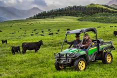
Ranches predominantly operate in rural areas far from the urban locations where cellular connections are unavailable. This means there is a large digital communications gap for ranches throughout the world. Whether it is knowing where individual cattle are located during round-up or mapping cattle grazing on isolated pastures to plan rotational moves to other pastures, satellite connected information allows ranchers to monitor activity based on actual livestock location and need. Winecup Cattle Co. runs on summer pasture across 40 square miles of public forest where more than 10,000 head of cattle graze. Communication is key. Also making sure the team can communicate at all times is important too.
The Challenge
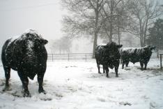
Nikki’s ranch, like so many, operates predominantly in remote locations across multiple state lines where communications are difficult, conditions are tough, and distances are long. They drive the herd in the best conditions possible, but this can mean operating in below freezing temperatures at elevations that can make standard communication impossible. Today the cowboys are often disconnected from homebase while working on the range. This creates gaps where there is no reliable back and forth communication.
The Solution
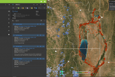
Addressing Winecup Cattle Co.’s first need for open communication, we shipped Globalstar SPOT X units to her ranch. These satellite communication units made it possible for the team in the mountains working the cattle to communicate via text. Having these Globalstar SPOT X units on GSatTrack meant homebase could track the team remotely. They created geofences around the some high mountain corrals that in the future could trigger text alerts from livestock proximity, for example, to know if cattle have moved outside the pasture. Map Layers in GSatTrack can provide additional information regarding weather conditions and elements that affect operations. This information could be relayed to the team gathering the herd and increase the overall productivity of the ranch and those working it. The SPOT X units' communication also afforded a member of Nikki’s team the opportunity to stay connected to his expecting wife while he was on the mountain, “This is your husband. Nikki gave me one of her satellite text machines so you can text this number if you go into labor.”
Another powerful benefit of the units tracked with GSatTrack were the paths and journeys taken by the ranch herd. This information and the routes taken could be saved to provide additional information regarding grazing logistics. Future satellite tags will provide animal locations to track pasture utilization.
To ensure Winecup Cattle Co.’s vehicles had communication and tracking as well, we outfitted one truck with an IDP-782 unit from Orbcomm to track location even when out of cell coverage. In the future when fitted with a Garmin screen, the truck operator will be able to see mapped locations and text with the team on the ground. The same SPOT X alerts received from GSatTrack could be sent to the vehicles to ensure efficiency.
The Result
The data generated by Winecup Cattle Co. in the field give the team a greater understanding of ranch logistics and communication needs. Future benefits include herd location, geofence alerts, and weather conditions. This information helps the team make decisions immediately with real-time intelligence and immediately change course if necessary to ensure safety and efficiency. Employing the Journeys feature from GSatTrack, they also has the ability to save routes and use them for future round-ups. The increased efficiency and improved resource allocation that accompany the outfitting of vehicles also allows them to coordinate corralling more effectively, making sure the right vehicles are in the right place at the right time.
Nikki looks forward to adding the GSatSolar to the mix, which will give even better intelligence related to the traceability of the herd. With the GSatSolar, Winecup Cattle Co. will have access to data that will make ranching more efficient, including pasture management, logistics coordination, and livestock activity monitoring. Leveraging that data, the team will not only be able to make better-informed decisions about the herd management and land stewardship, two things Nikki and West Sky Technology co-founder Kristine MacRae prioritize for their suite of ranching technology and services.


